Tokyo subway map
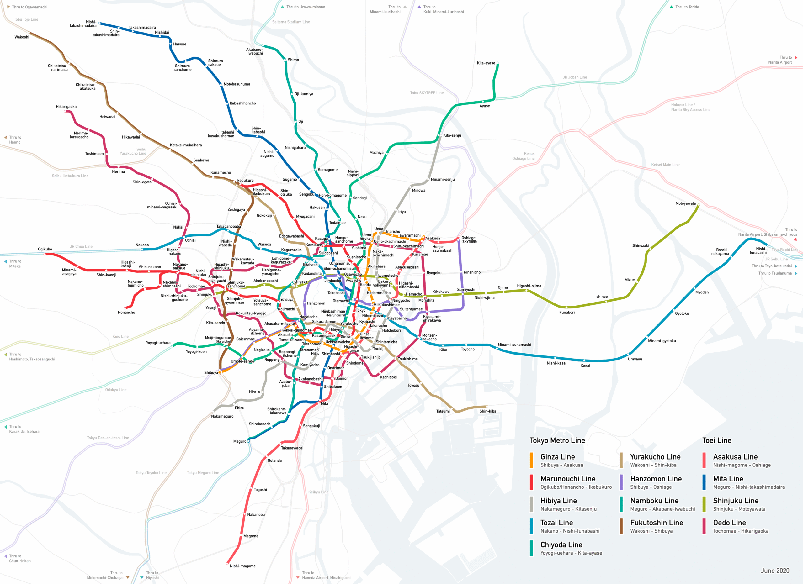
All thirteen lines and 216 stations on one map. Tap to enlarge, or download the PDF for your phone before you lose the signal underground.
The map as a PDF
Tokyo subway map · PDF
A vector PDF: it stays sharp however far you zoom in. Save it to your phone — there is no mobile signal in parts of the tunnels.
Subway map: adapted from “Tokyo Subway Linemap en” by Yveltal (Wikimedia Commons, CC BY-SA 4.0) by tokyosubway.org — the four Toei line colours, changed to the values the operators publish as open data. This adaptation is published under CC BY-SA 4.0 as well. It is not the operators’ official map.
How to read the map
Each line has its colour and its letter, and they are the same on the map, on the station signs and on this site. A station’s letter-and-number code tells you both the line and how far along it you are: G09 is the ninth station of the Ginza Line counting from Shibuya. Where two lines meet, the station carries both codes.
What the map does not show is which company runs which line, and that is what decides your fare. The four Toei lines are Asakusa (A), Mita (I), Shinjuku (S) and Oedo (E); the other nine are Tokyo Metro. The table below is the quickest way to check before you buy a ticket.
The map is a diagram, not a street plan: the distances on it are not to scale, and two stations that look adjacent can be a long walk apart.
| Line | Operator | Stations | Route |
|---|---|---|---|
| GGinza Line | Tokyo Metro | 19 | Shibuya ↔ Asakusa |
| MMarunouchi Line | Tokyo Metro | 28 | Ogikubo ↔ Ikebukuro |
| HHibiya Line | Tokyo Metro | 22 | Naka-meguro ↔ Kita-senju |
| TTozai Line | Tokyo Metro | 23 | Nakano ↔ Nishi-funabashi |
| CChiyoda Line | Tokyo Metro | 20 | Yoyogi-uehara ↔ Ayase |
| YYurakucho Line | Tokyo Metro | 24 | Wakoshi ↔ Shin-kiba |
| ZHanzomon Line | Tokyo Metro | 14 | Shibuya ↔ Oshiage (Skytree) |
| NNamboku Line | Tokyo Metro | 19 | Meguro ↔ Akabane-iwabuchi |
| FFukutoshin Line | Tokyo Metro | 16 | Wakoshi ↔ Shibuya |
| AAsakusa Line | Toei Subway | 20 | Nishi-magome ↔ Oshiage (Skytree) |
| IMita Line | Toei Subway | 27 | Meguro ↔ Nishi-takashimadaira |
| SShinjuku Line | Toei Subway | 21 | Shinjuku ↔ Motoyawata |
| EOedo Line | Toei Subway | 38 | Tochomae ↔ Hikarigaoka |
Transfers the map draws as two stations
In 17 places the operators treat two differently named stations as one transfer: you walk between them, usually through a passage, and the journey counts as one. They are easy to miss on a map that gives them separate names and separate dots.
| Station | Transfer to | Distance between platforms | On foot (estimated) |
|---|---|---|---|
| Akasaka-mitsuke | Nagatacho | 220 m | about 4 min |
| Akihabara | Iwamotocho | 260 m | about 4 min |
| Awajicho | Ogawamachi | 90 m | about 2 min |
| Awajicho | Shin-ochanomizu | 290 m | about 5 min |
| Bakuro-yokoyama | Higashi-nihombashi | 170 m | about 3 min |
| Ginza | Ginza-itchome | 300 m | about 5 min |
| Hibiya | Yurakucho | 190 m | about 3 min |
| Kasuga | Korakuen | 60 m | about 2 min |
| Kokkai-gijidomae | Tameike-sanno | 180 m | about 3 min |
| Naka-okachimachi | Ueno-hirokoji | 310 m | about 5 min |
| Naka-okachimachi | Ueno-okachimachi | 290 m | about 5 min |
| Ningyocho | Suitengumae | 440 m | about 7 min |
| Ogawamachi | Shin-ochanomizu | 230 m | about 4 min |
| Shinjuku | Shinjuku-nishiguchi | 160 m | about 3 min |
| Shintomicho | Tsukiji | 310 m | about 5 min |
| Toranomon | Toranomon-hills | 380 m | about 6 min |
| Ueno-hirokoji | Ueno-okachimachi | 40 m | about 2 min |
Distances are straight-line between the platform coordinates the operators publish. The walking time is our estimate from that distance — no operator publishes transfer walking times, and the real walk through a concourse is longer than the straight line.
What is out of date on this map
The free map is from 2020 and we have corrected only what can be corrected cleanly: all the lettering in the file is vector outlines rather than text, so changing a word means redrawing it. Rather than patch it badly, here is what to ignore on the image itself — everything on the rest of this site is current:
- the “Nakameguro” spelling (the operators write Naka-meguro)
- the legend wording (“Toei Line”)
- the “June 2020” date stamp
- the grey “Thru to …” labels, which predate the 2023 Sotetsu/Tokyu link
The lines, the stations and their order are right: we checked all 216 stations against the operators’ own data, including Toranomon Hills, and the two extensions under construction are correctly absent.